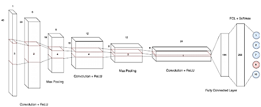
Remote sensing is the science of obtaining information about an object, area or phenomenon by the analysis of data acquired by a device that is not in contact with the object, area or phenomenon. Remotely sensed data is acquired in the form of electromagnetic energy emitted or reflected by various earth surface features. Electromagnetic radiation is acquired in the visible, near infrared, short wave infrared, thermal and microwave regions. Sensors measuring electromagnetic spectrum are ground based, air borne or space borne. Sensors for remote sensing have four characteristics that is spectral, spatial, temporal and radiometric. Spectral resolution is defined as number of bands and bandwidth of the bands. Spatial resolution is defined as the minimum size of an object a sensor can measure. Temporal resolution is defined as number of times a sensor over the same area. Radiometric resolution is defined as quantisation level of sensor. Remote sensing sensors can be either multispectral or hyperspectral based on the spectral resolution. Multispectral refers to usually 5 to 10 discrete bands. ResourceSat-2, ResourceSat-2A are Indian remote sensing satellites which have on board 3 multispectral sensors named Advanced Wide Field Sensor(AWiFS) , Linear Imaging Scanner Sensor(LISS-VII) and LISS-IV. Other satellites with multispectral channels Landsat, MODIS, Sentinel. Hyperspectral refers to 100 to 400 discrete bands. Indian hyperspectral sensors were flown in Indian Micro satellite-I and Chandrayan-I. Next Generation Airborne Visible/Infrared Imaging Spectrometer (AVIRIS – NG) has been developed by JPL(NASA) and has been used for various airborne missions. The AVIRIS-NG can take observations over a continuous electromagnetic spectrum spread over 380nm – 2510 nm at 5 nm band interval with spatial resolution of 4-8m over a flight swath of 2.5-5.0 km when the flight altitude is about 4–8 km. Hyperspectral imaging has advantages over multispectral imaging. The former can detect more materials or surface types such as minerals, rocks, vegetation, snow. It relates directly to surface chemistry. It can estimate the abundance of material present. This greater information content enables new methods for detection, characterisation and quantification in a broad range of Earth system environments Hyperspectral data has disadvantage of curse of dimensionality as it may contain many correlated bands. Increase in data volume pose greater challenges in data handling. Processing hyperspectral is slower compared to multispectral. The objective of the study was to discriminate crops of Anand, Gujarat site using the hyperspectral images acquired by AVIRIS-NG sensors based on Deep Neural Network classification techniques.